GRID REFERENCES
COORDINATES
THE GRID SYSTEM
Australian topographic maps produced after 1994 use the Map Grid of Australia (MGA) projection which is a Transverse Mercator projection. At its simplest, this coordinate system consists of a series of vertical and horizontal lines.
The vertical lines are called eastings. They are given in metres and their value increases in an easterly direction.
The horizontal lines are called northings. They are also given in metres and their value increases in a northerly direction.
The squares formed by intersecting easting and northing lines are called grid squares.
A grid coordinate also called grid reference indicates a location on a map: they consist of an easting and a northing values. Eastings are given first.
The easting line labelled 270000mE means that the line is 270000 m or 270 km east of a given origin.
The northing line labelled 6275000mN means that the line is 6275000 m or 6275 km north of a given origin.
The smaller digits are dropped on the edges of their maps. For example easting line 269000mE is written 69 and northing line 6276000mN is written 76 on the map.
GRID REFERENCES
A grid reference indicates a location on a map. A full grid reference includes:
- a unique grid zone identifier
- an easting value given in m.
- a northing value given in m.
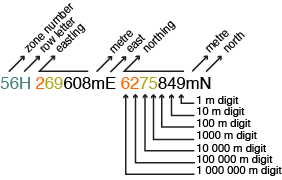
This is a full grid reference given by a GPS: 56H 269608 6275849.
- The grid zone identifier is: 56H
- The easting value is: 269608 m.
- The northing value is: 6275849 m.
MAKING SENSE OF EASTING AND NORTHING VALUES
Eastings and northings are distances measured in metres.
The easting value 269608 represents a distance of 269608 m east of some origin. The northing value 6275849 represents a distance of 6275849 m north of some origin.
On a map, the 100000 m values for both eastings and northings are shown in small font.
For instance, the 100000 m value is 2 in the 269608 easting and 62 in the 6275849 northing.
In land navigation, the 100000m values do not need to be given as long as the map used is specified. this reduces the coordinate to a ten-figure grid reference such as 69608 75849, Springwood map – 2017 edition.
Once reduced to a ten-figure grid reference, notice that the 1000 m values for both eastings and northings are shown in a bigger font on the edge of the map.
For instance, the 1000 m value in the 69608 easting component is 69 and 75 in the 75849 northing component.

HOW MANY FIGURE IS ENOUGH? ten? Eight? Six? FOUR?
A four-figure grid reference identifies a location within a 1 km by 1 km grid square: for instance 69 75.
Click here to learn how to read or plot four-figure grid references on a map.
A six-figure grid reference identifies a location within a 100 m by 100 m grid square: for instance 696 758.
An eight-figure grid reference identifies a location within a 10 m by 10 m grid square: for instance 6960 7584.
A ten-figure grid reference identifies a location within a 1 m by 1 m grid square: for instance 69608 75849.
For land navigation, six-figure grid references are enough!IN SUMMARY
Easting: vertical lines on a topographic map. Number increases from left to right.
Northing: horizontal lines on a topographic map. Number increases from bottom to top.
Grid Reference: coordinate made up of a grid zone identifier, an easting value and a northing value.
FULL GRID REFERENCE
-
- The grid zone identifier is: 56H
- The 100000m identifiers are: 2 in the easting component and 62 in the northing component: these are the small leading numbers written on the edge of the map.
- The 10-figure grid reference is: 69608 75849.
- The 4-figure grid reference is: 69 75.: these are the large numbers written on the edges of the map.
- The 6-figure grid reference is: 696 758: drop the last two digits from the easting and northing values.
- The 8-figure grid reference is: 6960 7584: drop the last digit from the easting and northing values.

